My Green Laning
In the South East UK there are some 34,000km of recorded Public Rights
of Way : less than 5% of this is available for motorised users.
Most of those routes are several centuries old - cattle
drove roads, abandoned turnpikes, winter routes for when the road in the
valley was impassably muddy (but has since been tarmaced), and so on.
These are marked as BOATs (byway open to all traffic) or RUPPs (road
used as a public path) on Ordnance Survey maps. There are also unsurfaced
"Unclassified County Roads" - public roads which escaped the tarmac
gangs in the mid 1900s, but they can be harder to find. Some
of those are getting "ORPA" (other routes with public access) markings
on the latest OS maps ... but even then it's not clear if they have recognised
motor rights or not. Join a club to ask other local users, or ask at
the council offices.
If you use Streetmap's webpage, on some zoom settings
it shows OS Landranger style mapping including Rights of Way. (BOAT
symbol +-+-+-+)

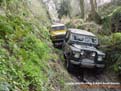
I drive these routes, often with my family, in our aging Range Rover.
We used to have a "proper" Series 3 Land Rover - but comfy seats,
power steering and a heater that sorta works have a powerful allure
...
 Temporary photo - looks like it, but not mine!
It makes an excellent day out with a picnic etc., we have got
to see much of the "secret" countryside and historic sites &
routes. We're members of a local Land Rover club, who also
organise other activities away from the public roads, from muddy play-days
to competitive trials on private land etc. I recommend anyone
interested in using their 4x4 to join a local club ! Oh ...
and it doesn't have to be a Land Rover, but well ... they
are British old chap ;) ![]()
Useful links for 4x4 clubs and so on. See also other organisations
here
.
 www.hbro.co.uk/
My local club - Hants
& Berks Rover Owners
www.hbro.co.uk/
My local club - Hants
& Berks Rover Owners www.awdc.co.uk/
All Wheel Drive Club, a national
club, and not just Land Rovers
www.awdc.co.uk/
All Wheel Drive Club, a national
club, and not just Land Rovers www.4x4web.co.uk/
various useful 4x4 links and stuff
www.4x4web.co.uk/
various useful 4x4 links and stuff