Saxons occupied the Weald and the name Witley is said to derive from 'Witta's leah' or clearing. In 1066 came the Norman conquest. Twenty years later King William's Domesday Book was finished. It gives details of all lands held from the King. In it Witley, Hambledon and Tuesley are mentioned, but not Chiddingfold, Haslemere or Thursley. Witley was held by Gilbert, who was of Norman family; his grandfather is said to have fallen at the Battle of Hastings, so it seems Witley was assigned to his family as a reward for military services. Witley had roughly 1500 acres under cultivation, 40 families, land for 16 ploughs and woodland for 30 pigs. It had its Church. Thursley had a chapel which was attached to the Church at Witley. There was no mill. Godalming had three mills and was about twice the size of Witley.
Somewhat younger than Witley Church is Oxenford Grange in the north of the parish. The word grange means a farm attached to a religious foundation. Oxenford was attached to Waverley Abbey near Farnham, the first Cistercian monastery in Britain, founded in 1128. (In the 1840's, the architect A.W.Pugin, who worked on the Houses of Parliament at Westminster, was commissioned to reconstruct a thirteenth century farm at Oxenford; Pugin died of overwork in 1852, before the farm was completed.)
The Lord of the Manor of Witley presided from the Courthouse, which was just north of the Church on the same side of Witley Street. Cottages lay together along this Street, along Wheeler Street a little further towards Godalming and along Milford Street. The Lord's lands totalled several hundred acres in Witley and Thursley and included LeLord's Pond, next to the King's way in Witley. Elsewhere in the parish there were little groups of one or two cottages in a pattern of settlement not very different from the present. The best years of this rural life were probably around the thirteenth century, the years of great cathedral building, with strong Church authority and with a warm climate. Rising with the sun and retiring at sunset, men would have enjoyed the quietness of the countryside, with abundant animals and wild flowers. In 1347 came the Black Death, which took a third of the population. With reduced numbers it was difficult to work the land and this led to strife between landowners and peasants.
There was a royal deer park, Witley Park, from the thirteenth century or earlier. In 1548 it was six miles in circuit, extending southwards from Park Lane west of Brook. Its western border probably followed the parish boundary through Creedhole and up around the top of Inval Hill and descended into Grayswood. The Moat by the modern South Park Farm was probably linked with this Park, though a search for written evidence has not shown a direct connection. The Park's eastern boundary was not far from the way from Brook to Birtley. The 300 fallow deer in the Park would sometimes have been visible in the beautiful views southwards from Park Lane. Poaching in the Park was always a problem and the park pale was demolished in 1549 in a rebellion, largely against enclosure of land. Thomas Jones held the Keepership of the Park at this time. His father was one of the Sewers of the Chamber of Henry VIII; this job involved trying out the King's food to make sure that it was good to eat and free from poison. Jones held 100 acres at Sattenham and in 1576 was in dispute with John Mellersh, who flooded some of this land to get better water power for Rake Mill. Mellersh infringed on the Lord's private way, refused to cooperate with authorities and lost his case. In 1602 and later Henry Bell enlarged and beautified Rake House by the Mill.
Godalming was prominent as a wool town. Rake Mill was a fulling mill for cloth and many of the cattagers were weavers, like the Payne family at Step Cottage below the Church and Thomas Stynt of Red Rose Cottages. The Chitty family of Milford and Witley, clothiers, were tenants of Chesberies (Chisberry) in 1566. This house by Wheeler Street dates from before 1310, when it was associated with William de Chussebury de Muleford (Milford).
Distinct from the Manor of Witley, there was a small Manor of Witley Rectory, sold by Henry VIII to Thomas Jones in 1544. This includes Parsonage Farm, smaller properties and rights of Church administration. In 1626 Cheseburies was included. The Lunn family were associates with this Manor, and also with the White Hart pub by the Church, so the White Hart may have been of Witley Rectory.
The site of the house now called Witley Manor, opposite Witley Church, belonged to the Ede family. In 1673 Richard Ede granted a lease of Vine Tree House there, with 60 acres of land, to his son-in-law John Chandler. Members of the Chandler family were Vicars of Witley for many years. In the nineteenth century it was common for them to conduct a service in Witley in the morning, walk to Thursley for a second service in the afternoon, and speak in Milford in the evening.
In 1596 Witley Park was about 3 miles in circuit. It contained but 400 acres, of which there were in meadow 2 acres, in pasture 100 acres with the rest wood and heath. There was a lodge, two barns and a stable, and a keeper's cottage a quarter of a mile from the lodge. From about 1588 there had been only 100 fallow deer. The Park was in decline and soon was parcelled out into farms. At this time local iron-working came to prominence, notably by the Hammer Pond on Witley and Thursley heaths. An iron furnace was located by Wareham Rew just south of Brook. Ore was dug from small pits; coppice woods and charcoal burning were organized and ponds were created to store water to power the bellows. These ponds were used to breed carp, some of which reached the great weight of 30 lbs. Increased numbers of people were employed and new cottages were built. The self-contained character of rural life was disturbed as trading and travelling increased. The wealden iron industry declined in the later seventeenth century. In 1735 coal was discovered as a fuel and the industry relocated further north. Local clay was used for making bricks; a brick kiln and drying sheds existed south of Brook until the 1950's.
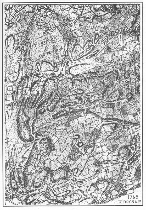
By the mid eighteenth century, regular coach travel started up and Turnpike roads began to appear. One of the first good maps was by the Frenchman J. Rocque. That reproduced here is from his first edition for Surrey, about 1768. It covers the area of the Manor of Witley, which extended into Thursley and south around Haslemere. Resemblances between Rocque's map and modern Ordnance Survey maps are generally wonderful. Rocque's map omits some places such as Rice's Farm and Shoelands near Birtley. The individual communities of Milford and Mousehill are shown. The Manor of Corte in Mousehill dates from the fourteenth century and there were tenements and common fields in Milford at that time. Rocque's map shows settlements close to the present location of Milford Lodge. The Tuesley family were at Leyland in 1479. In 1675 they owned Leigh House, Leighland alias Adams (Leigh Farm) and Lemanland. Roke Lane was called Leman Lane, the muddy way and is said to be very ancient. Leigh House and Leigh Park became Lea Park.
Acts of enclosure in the later eighteenth and nineteenth centuries curtailed the freedoms of the independent working countrymen, much to their chagrin. These acts led to consolidation of estates, with many exchanges of property. In 1859 the railway came to Witley. This brought the country within easy reach of London and led Londoners to live in the parish; The population increased. Lea Park was walled by Whitaker Wright at the end of the nineteenth century. The estate was extended southwards close to Haslemere by Lord Pirrie, Belfast shipbuilder in the early 1900's. He enclosed large tracts of land with fine iron fencing. This may still be found in many places embossed with the letter P. In 1923 he gave the village hall at the cricket ground at Brook. Sir John Leigh succeeded Lord Pirrie; he changed the name Lea Park to Witley Park. The ancient royal deer park and the modern Witley Park are not the same.
Amongst special people and institutions lately in the community, King Edward's School came from London to Wormley in 1860. The novelist George Eliot lived at Witley Heights and there completed her last novel, Daniel Deronda. Birket Foster, engraver and watercolourist, was buried in Witley churchyard in 1899. Helen Allingham came and lived at Sandhills, Brook, in 1881; she painted romantic watercolours of landscapes and cottages. At the turn of the century Gertrude Jekyll, famous as a designer of gardens, recorded cottage life in photographs.
The parish encompasses some of the finest countryside in England and the National Trust has owned the 377 acres of Witley Common since the 1920's; an interpretive centre was opened in 1976. The Institute of Oceanographic Sciences came to Wormley in 1952; the sonar developed here for mapping the ocean floor, called Gloria, has become world-renowned. Virginia Bottomley, Health Minister in the present government, makes her home in Milford. As ever, the parish of Witley is bright and distinctive.