
Ordnance Survey Sheet SD 66 SE (1956) (6" to 1 mile) shows a farm called "Balshaw" (at grid reference 6734 6440). It is on Tatham Fell in the civil parish of Tatham, (although it is some miles from the village of Tatham) in Lancashire. It is on Balshaw Road which leads to Balshaw Bridge (at grid ref. 6730 6465) both of which can still be seen on the 1984 1:25,000 series OS map, sheet no. SD 66/76. The house was apparently pulled down in about 1962 when the estate was sold. Only a few stones on a grassy mound remain. This information was given to Mr Robert Bassendon (to whom I am indebted for supplying the details) by an elderly farmer at a near-by farm. The farm was also know as "Higher Balshaw" at some time in the 1800s. Balshaw Bridge carries the road over Crossdale Stream. The stream (and dale) presumably take their name from the "Cross of Grete" which is shown at the head of the dale on a 1610 map of Lancashire by Speed. The remains still stand by the Slaidburn road (at grid reference 683608).
However, having found some earlier maps of the area, it appears that this was not the house that originally bore the Balshaw name. Instead, the house now known as "Tunstall House" appears to have been called "Balshaw" until at least 1829. This house was at some time known as "Lower Balshaw".
Click on the map to get to another copy of the map showing where the photos were taken from,or follow this link to find a page of photographs of the area.
1891 Census
On the 1891 census the farm called "Balshaw" is mentioned. It is on the census return for Tatham Fells in the registration district of Lunesdale, sub district Wray, enumeration district No 7 Schedule 12. The farmer is Nathaniel Walker, age 39, born in Bentham, Yorkshire. His wife Agnes (age 38) and six children also lived at the farm. The four youngest children (aged 7 and below) were born in Tatham, Lancashire, presumably at the farm. The older two were born in Bentham (3 or 4 miles to the north). This suggests that Mr Walker had recently taken up the tenancy of the farm and that his father was not the previous tenant.
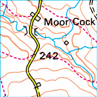
This is a modern map of the immediate area of the former Balshaw Farm. The farm was about at the position of the point at the bottom left of the first "2" in the height measurement of 242m above sea level. This map corresponds to one grid square on an Ordnance Survey map, and it is 1km square.
You can find this map and the surrounding area by following this link to http://www.streetmap.co.uk/streetmap.dll?grid2map?X=367640&Y=464400&zoom=1
Or see links to other maps on the internet.